
Key Markets
3D Scanning
The market for Simultaneous Localisation and Mapping (SLAM) handheld scanners sits at the intersection of 3D scanning, mobile LiDAR, and SLAM software technology. Because market intelligence firms evaluate the broader SLAM technology market, 3D laser scanners, and structural inspection hardware independently, growth projections vary by scope.
Global Growth Outlook: The global market for SLAM technology and mobile handheld 3D scanning is undergoing rapid expansion, primarily driven by indoor mapping, infrastructure management, mining, and spatial digital twins.
SLAM Technology Overall: The global SLAM technology market is projected to expand at a Compound Annual Growth Rate (CAGR) of 28.0% to 49.4%. Total market valuations are expected to surge from ~$3.1 billion–$3.9 billion to over $36 billion by the mid-2030s.
3D Handheld Scanners & Mobile LiDAR: For handheld hardware specifically (combining 3D spatial scanning, structural inspection, and mobile LiDAR), growth is projected at a CAGR of 9.1% to 11.5%, expanding the global segment to $6.1 billion–$8.2 billion by 2034.
Key Global Drivers: Rapid adoption of Building Information Modeling (BIM) and Digital Twin creation in architecture, engineering, and construction (AEC).
Integration of high-density LiDAR with Visual-Inertial SLAM (vSLAM) algorithms for GPS-denied locations like mines, tunnels, and dense forests.
Australian (and Asia-Pacific) Growth Outlook: Australia is a key regional adopter of mobile SLAM handheld hardware, driven heavily by local mining operations, forestry, and major infrastructure projects.
Regional CAGR: Australia falls into the Asia-Pacific (APAC) regional bracket, which is currently the fastest-growing region globally for SLAM and 3D reconstruction technologies, projecting a CAGR of 11.4% to 12.4% for 3D scanning hardware and up to 50.6% CAGR for core SLAM tech integration.
Key Australian Market Drivers: Mining & Underground Exploration: High domestic adoption of handheld and mobile SLAM systems (e.g., GeoSLAM, Emesent Hovermap, Leica BLK2GO) for rapid stock volume calculation, shaft mapping, and void inspection where GPS is unavailable.
Infrastructure Rehabilitation: Major civil engineering projects across New South Wales, Victoria, and Queensland mandate non-contact 3D dimensional verification and BIM integration.
Forestry & Environmental Management: Increasing reliance on handheld LiDAR scanners to conduct rapid canopy density and biomass assessments across rural Australia.
Market Comparison Summary: Metric / DimensionGlobal MarketAustralian / Asia-Pacific MarketCore SLAM Tech Growth (CAGR)28.0% – 49.4%~50.6%Handheld 3D Hardware Growth (CAGR)9.1% – 11.5%11.4% – 12.4%
Dominant Use Cases: AEC (BIM), Autonomous Systems, Industrial PlantsMining, Underground Tunnels, Construction, Forestry. Call 1300 20 54 30 for more information or click here
LiDAR
Unlocking the Future of Asset Digitisation
We are operating in an era where rapid, highly accurate data is the most valuable asset a company can leverage. At AQScan Australia, we provide the digital foundation that modern businesses need to thrive. By harnessing the combined power of Artificial Intelligence (Ai), Aerial & Ground SLAM, LiDAR, and Thermal technology, we are redefining how key markets capture, manage, and interact with their physical infrastructure.
Our core philosophy is simple: Power in Every SCAN. We deliver Faster, Safer, and Smarter data that translates directly into reduced Operations and Maintenance (O&M) costs and elevated Returns on Investment (ROI).
The Technology: Aerial & Ground Precision
The true power of AQScan lies in our versatile data capture capabilities. By utilizing a hybrid approach of Drone (Aerial) and Handheld (Ground) LiDAR mapping, no environment is out of reach.
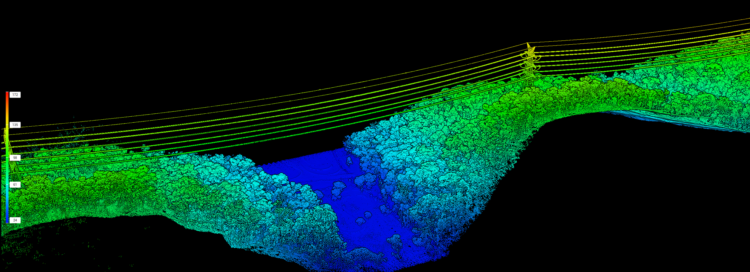
Drone (Aerial) LiDAR: Ideal for capturing vast topographies, large-scale infrastructure, and inaccessible or hazardous terrains from above with millimeter precision.
Handheld SLAM LiDAR: Simultaneous Localization and Mapping (SLAM) allows operators to walk through complex indoor environments, underground spaces, or dense facilities, building a complete, high-density 3D digital twin in real-time
Key Market Opportunities
The deployment of these advanced scanning technologies is creating unprecedented opportunities across major industrial sectors:
1. Construction & Engineering
Modern construction relies heavily on minimizing rework and adhering to strict timelines. LiDAR and SLAM allow for rapid "as-built" verifications against original architectural models. Project managers can conduct precise clash detection, monitor daily site progress, and ensure structural integrity without halting ongoing work.
2. Mining & Resources
Safety and efficiency are paramount in the resources sector. Drone LiDAR safely captures high-resolution volumetric data of stockpiles, open-pit mines, and extraction sites in a fraction of the time required by traditional surveying. Ground SLAM safely navigates and maps underground tunnels and hazardous confined spaces, keeping human personnel out of harm's way.
3. Utilities, Energy & Asset Management
Aging infrastructure requires constant monitoring to prevent catastrophic failures. The integration of Thermal technology with our LiDAR scanning allows for the early detection of energy loss, structural anomalies, and equipment wear. Digitizing these large-scale assets creates an accessible "single source of truth" for predictive maintenance, dramatically reducing facility downtime.
The AQScan Advantage
When organizations partner with AQScan, they aren't just getting raw data—they are getting actionable, intelligent insights.
Faster: Rapid deployment and automated Ai processing cut data turnaround times from weeks to hours.
Safer: Remote aerial scanning and rapid ground mapping drastically reduce the time personnel spend in high-risk zones.
Smarter: AI-driven analytics turn dense point clouds into clear, measurable digital assets.
By empowering decision-makers with a precise digital reality, AQScan reduces manual labor costs, mitigates project risks, and drives sustained operational efficiency. We invite you to join our network of professionals and transform how you manage the physical world.
Ai
Drone Tech
Thermal


Become a AQScan Partner today. Send us your contact details and our team will call you to discuss the partner opportunities that are in your area.
You will also recieve your AQScan Complimentary Partner Info Pack and VIP Discount code to use at our Partners atEnterprise Drones Store.
Call 1300 20 54 30 if you would like to speak to the team now.